The Yellowstone Trail
Across Washington State
Before there were numbered US highways, the Yellowstone Trail route was the first coast to coast
automobile route that went entirely across the northern part of the United States. The route was
named the Yellowstone Trail because it was the northern route that most people traveled to reach
Yellowstone National Park.
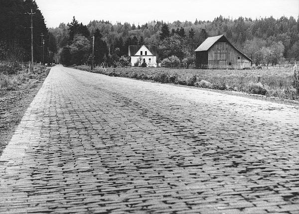
I photographed the above scene in November 1975, just east of Redmond, Washington, inspired by a
Josef Scaylea black and white photograph of the same scene in The Seattle Times. Having seen
compelling black and white photographs by Josef Scaylea was partly what got me into developing and
printing, in a darkroom, my own black and white film and photographs, in the 1970s. This scene shows part
of the only unaltered remnant of the Yellowstone Trail automobile route in King County, Washington. This
scene of the old Yellowstone Trail route is looking south down present-day 196th Avenue NE from near the
present-day intersection with NE 61 Place, which didn't exist in 1975.
Before this red brick road was paved it was named the James Mattson Road after a landowner along the
west side of the road, who originally petitioned to have the road built. The circa 1901 road was later paved
as the Redmond-Snoqualmie Road, in 1913, with vitrified red paving brick from the Denny-Renton Clay
& Coal Company. In 1983 the over one mile long red brick road was designated a King County
landmark and in 1989 was carefully restored to preserve the road as a Washington State centennial project.
At present the old red brick road looks much the same now as it does in my 1975 photograph, but the
surrounding countryside has been somewhat encroached upon by urban sprawl since then.
The Yellowstone Trail route was established by the Yellowstone Trail Association, a grassroots organization
that formed in October 1912 as an advocate for good roads. A slogan of the Yellowstone Trail Association,
printed on route brochures, was “A Good Road from Plymouth Rock to Puget Sound.” The
Yellowstone Trail route was pieced together, connecting from road to road, using the first existing good
roads constructed across the northern part of the United States.
Across Washington State the Yellowstone Trail route originally was a circuitous route that was designated
by about 1915, when the Sunset Highway automobile route over
Snoqualmie Pass was
dedicated and replaced the route of the old
Snoqualmie Pass wagon road (State Road No. 7). Before the Sunset Highway was constructed the old
wagon road was improved over a two year period beginning in 1910 and was formally opened for traffic
on July 17, 1912, as a temporary route for automobiles, which were ferried on Lake Keechelus by Finch
Brothers gas-powered ferry Wahkiakum for a minimum ferry fare of $2.50. A Certificate of
Inspection was first issued for the Wahkiakum in July 1911 and the ferry was operated by Sidney
Gordon Finch and Emery Josiah Finch. This article only describes in detail the Yellowstone Trail route
as it first existed across Washington State after the Sunset Highway was
dedicated on Thursday July 1, 1915, by
Governor Ernest Lister at Snoqualmie Pass.
Later the Yellowstone Trail route coincided with the route of the Sunset Highway from Spokane to Seattle.
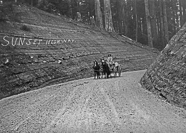
Shown above is the Yellowstone Trail route on the Sunset Highway, below Snoqualmie Pass, soon after
completion of gravel surfacing. The Snoqualmie Pass stretch of the Sunset Highway was opened for
traffic by October 1, 1914, although gravel surfacing had not been completed by that time and the
highway wasn't formally dedicated until July 1, 1915. The P.J. McHugh Paving & Construction
Company, owned by Patrick J. McHugh, constructed the summit stretch of the Sunset Highway, doing the
clearing, grading and bridging work from Gold Creek east of the summit to within about four miles of North
Bend west of the summit. When the Sunset Highway replaced the route of the old Snoqualmie Pass wagon
road the new highway was first used by both wagons and automobiles.
Westward from Spokane, the Yellowstone Trail route originally used the old Inland Empire Highway, which
meandered hill and vale through Rosalia, Colfax, Central Ferry, Dayton, Walla Walla, Pasco, Kennewick,
Richland, Prosser, Grandview, Yakima, Selah, Wenas, and Ellensburg. Between Selah and Ellensburg, the
Inland Empire Highway and the Yellowstone Trail route originally went from Selah on the route of the 1870s
stage road, up through the Wenas Valley past Chief Ow-hi's Gardens, Wenas, and on up over the
west end of Umtanum Ridge through Ellensburg Pass, which at an elevation of 3128 feet was higher than
the original 3010-foot summit of the Sunset Highway through
Snoqualmie Pass. From Ellensburg Pass the
Yellowstone Trail route went down through Shushuskin Canyon (named after Chief Shu-shu-skin) and then
down onto the Kittitas Valley bottom. An 1880s cutoff along this route, the Jacob Durr Toll Road, was also
used by stagecoaches, but it was a more rugged route over Umtanum Ridge than the original 1870s stage
road, so it was not used as part of the Yellowstone Trail route.
From Ellensburg, the Yellowstone Trail route went west on the route of the Sunset Highway through Cle Elum.
The Sunset Highway originally came through Ellensburg from Spokane by way of Davenport, Wilbur,
Waterville, Wenatchee, Quincy, and Vantage, but by the early 1920s it was routed from Wenatchee on up
over Blewett Pass and down through Cle Elum. In 1925, after the later Sunset Highway route over Blewett
Pass was improved, the Yellowstone Trail route was designated as using that more direct route from
Spokane to Cle Elum.
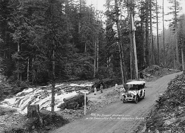
Shown above is the Yellowstone Trail route beside Weeks Falls on the South Fork Snoqualmie River. The
car shown is a 1913 Packard Model 1-38 Touring Car. The 1913 five-passenger Packard
“38” had a 6-cylinder, 415-cubic-inch, 60-horsepower engine and that year of manufacture
the Packard “38” was the first Packard to feature both electric headlights and an electric
starter. The car shown has an AAA emblem on the radiator grill and a 1916 Washington State license plate,
which dates this photograph to that year. The man standing beside the car is possibly photographer Asahel
Curtis, remotely triggering the camera shutter electrically using a connected battery wire. The handwritten,
underlined, photo caption is the same style as that found on various postcards and larger photographs that
were published by the Scenic Photo Publishing Company, in Seattle, Washington. Some of these larger
Sunset Highway photographs, having that same style of handwritten, underlined, photo caption are rubber
stamped on the back “Asahel Curtis, Commercial Photographer, Seattle, Wash.”
From Cle Elum, the original Yellowstone Trail route continued on the route of the Sunset Highway through
Easton, Snoqualmie Pass, North Bend, and
Snoqualmie, to Fall City. At Fall City the original Yellowstone Trail route departed the original Sunset
Highway route, which originally continued on through Preston, High Point, Issaquah, Renton, and then on
around the south end of Lake Washington.
From Fall City the Yellowstone Trail route wound northwestwardly generally on the route of the present-day
Redmond-Fall City Road (SR 202) for about 12 miles and then angled off northwestwardly on present-day
NE 55th Place over to present-day 196th Avenue NE. From present-day NE 55th Place the Yellowstone
Trail route went north on present-day 196th Avenue NE for nearly 1¼ miles to present-day NE Union
Hill Road. From there the Yellowstone Trail route turned west and wound westwardly on the routes of
present-day NE Union Hill Road, NE 80th Street, Avondale Way NE, and NE 79th Street, to Redmond Way
in downtown Redmond.
In downtown Redmond the Yellowstone Trail route continued about a couple blocks on present-day Redmond
Way and then turned onto present-day Leary Way NE, going southwestwardly past the Redmond Depot on
the east side of the road and then across the railroad tracks of the Northern Pacific Railway, Snoqualmie
Branch. From the railroad crossing, the Yellowstone Trail continued on present-day Leary Way NE, crossed
the Sammamish River and then meandered westwardly generally on the routes of present-day West Lake
Sammamish Parkway, Old Redmond Road, NE 70th Place, NE 70th Street, NE 72nd Place, and NE 68th
Street, then crossed under the tracks of the Northern Pacific Railway, Lake Washington Belt Line. From this
second railroad crossing, the Yellowstone Trail continued generally on the routes of present-day NE 68th
Street, State Street South, and then down Kirkland Avenue to an automobile ferry landing on the downtown
Kirkland waterfront. Parts of this early automobile route between Redmond and Kirkland were designated
early on at various times as State Aid Road No. 4, State Aid Road No. 4-56, and as Permanent Highway
No.1 A. Part of this route, west of the Sammamish River Bridge for nearly a couple miles, was paved in the
autumn of 1911 with patented Warrenite Bitulithic Pavement and was one of the earlier bituminous hot mix
paving projects in Washington State.
The ferry Lincoln of Kirkland provided a connection across Lake Washington from Kirkland to the
ferry landing at the foot of the east end of Madison Street, in the Madison Park neighborhood of Seattle.
The ferry Lincoln was in service between Kirkland and Madison Park from 1915 until 1940, when the
Lacey V. Murrow floating bridge across Lake Washington opened. Earlier county-operated ferry boats
making the run were the King County of Kent and the Washington of Kirkland.
Today Madison Street still angles diagonally across Seattle, running from the location of the old ferry
landing on Lake Washington at Madison Park, directly to downtown Seattle and the Seattle waterfront on
Puget Sound.
<< BACK
|